
official data (NOAA / NHC Hurricane Rachel Public Advisory 18 + Discussion 18, 1500 UTC Thu Oct 1 2026)
Rachel: 105 mph and strengthening — NHC forecasts a major hurricane by Friday, heading out to sea
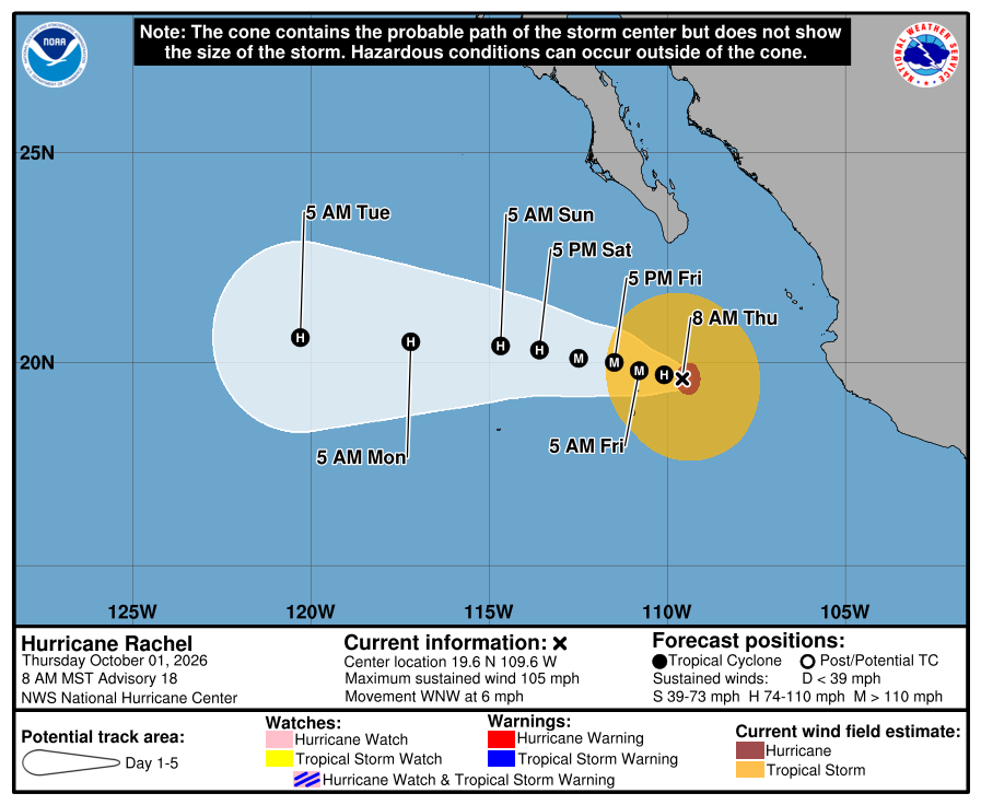
The National Hurricane Center’s Advisory 18 at 11 AM ET Thursday has Hurricane Rachel at 105 mph and 964 mb near 19.6 north, 109.6 west, about 230 miles south of the tip of Baja California, and forecasts it to become a major hurricane by Friday morning as it moves west, away from land. No coastal watches or warnings are in effect.
Key facts
- Adv 18 stamp (800 AM MST / 11 AM ET Thu Oct 1)
- Hurricane Rachel, Category 2 · 19.6N 109.6W · ~230 mi (370 km) S of the southern tip of Baja California · 105 mph (165 km/h) · 964 mb · WNW 6 mph
- Headline
- “…RACHEL STRENGTHENS…” · initial intensity raised to 90 kt (Discussion 18)
- Forecast (Discussion 18)
- 110 mph by 8 PM ET tonight · 115 mph (major, Category 3) by 8 AM ET Friday · peak 120 mph Friday evening (8 PM ET) · then gradual weakening over drier air and cooler water, 90 mph by Tuesday
- Brake
- Wind shear had been forecast to lessen but has not; NHC now expects it to stay moderate for about two days
- Track
- West-northwest to west at a slightly slower speed for the next couple of days, then west at a faster speed — into the open Pacific (Discussion 18 forecast positions)
- Watches / warnings
- No coastal watches or warnings in effect
- Wind / surf
- Hurricane-force winds extend 35 mi, tropical-storm-force 150 mi · swells will bring life-threatening surf and rip currents to west-central Mexico and the Baja California Peninsula through the end of the week
- Since Adv 17
- Advisory 17 (2 AM MST) had 100 mph and 972 mb near 19.4N 109.3W
- Live later
- Next complete NHC advisory 200 PM MST (5 PM ET) · major-hurricane upgrade → climate HUD — no invented landfall or toll
Maximum sustained winds have increased to near 105 mph (165 km/h) with higher gusts.
NHC Hurricane Rachel Public Advisory 18 · 800 AM MST Thu Oct 1 2026
Note
Rachel is still climbing. National Hurricane Center Advisory 18, issued at 11 AM ET Thursday, has the hurricane at 105 mph and 964 mb near 19.6 north, 109.6 west, about 230 miles south of the tip of Baja California, moving west-northwest at 6 mph. Discussion 18 forecasts 115 mph, a major hurricane, by 8 AM ET Friday, and a peak of 120 mph Friday evening, before drier air and cooler water start to wear it down. Shear that was expected to ease has not.
The forecast track bends west, into the open Pacific. No coastal watches or warnings are in effect; the swells it throws off will bring life-threatening surf and rip currents to west-central Mexico and the Baja peninsula through the end of the week. The next advisory is due at 5 PM ET and goes to the HUD.
Why it matters
Rachel keeps climbing and NHC still expects a major hurricane by Friday morning. This time the track carries it out to sea, and the coast gets the surf, not the core.
Sources
- NOAA National Hurricane Center — Rachel Public Advisory 18
- NHC Rachel Discussion 18
- NHC Rachel graphics (5-day cone)
- Earlier: Rachel Advisory 17 card (100 mph)
Primary + secondary attribution as listed.
More: Hurricanes & typhoons
Doom Signals desk · About · Contact · Corrections. Spotted an error? Write the desk; fixes go on the public log.