
official data (NOAA / NHC Hurricane Rachel Public Advisory 17 + Discussion 17, 0900 UTC Thu Oct 1 2026)
Hurricane Rachel: 100 mph and strengthening — NHC expects a major hurricane within a couple of days
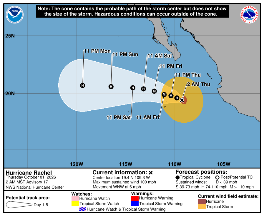
The National Hurricane Center’s Advisory 17 at 200 AM MST Thursday puts Hurricane Rachel near 19.4 north, 109.3 west — about 245 miles south of Cabo San Lucas — with 100 mph winds and a 972 mb pressure, and says Rachel is expected to continue strengthening and become a major hurricane within the next couple of days, while no coastal watches or warnings are in effect.
Key facts
- Adv 17 stamp (200 AM MST / 0900 UTC Thu Oct 1)
- Hurricane Rachel · 19.4N 109.3W · ~245 mi (390 km) WSW of Cabo Corrientes · ~245 mi (395 km) S of Cabo San Lucas · 100 mph (155 km/h) · 972 mb · WNW 6 mph
- Intensity (Adv 17)
- “Rachel is expected to continue strengthening and become a major hurricane within the next couple of days.” · Discussion 17 raised the initial intensity to 85 kt on improved convective organization
- Forecast peak (Discussion 17)
- 105 kt (120 mph) at 36 h, then gradual weakening over cooler water and dry mid-level air · intensity forecast above the guidance envelope in the short term
- Brake (Discussion 17)
- Easterly to northeast shear of around 15 kt may limit strengthening in the short term, forecast to relax
- Track
- West-northwest for the next couple of days, away from mainland Mexico and passing south of the Baja California Peninsula today, turning more west by the weekend
- Watches / warnings
- No coastal watches or warnings in effect · interests in southern Baja California Sur should monitor Rachel
- Rain
- Additional 2–4 in, isolated storm totals of 12 in, across coastal Guerrero, Michoacán, Colima and Jalisco — life-threatening flooding and mudslides possible, especially in steep terrain
- Wind / surf
- Tropical-storm-force gusts possible on parts of the southwestern Mexico coast today · hurricane-force winds extend 35 mi, tropical-storm-force 150 mi · life-threatening surf and rip currents spreading to west-central Mexico and the Baja peninsula through the end of the week
- Since Adv 14
- Advisory 14 (Wed 800 AM MST) had 85 mph and 978 mb near 18.1N 108.0W
- Live later
- Next complete NHC advisory 800 AM MST (11 AM ET) · any major-hurricane upgrade or Baja watch → climate HUD — no invented landfall or toll
Rachel is expected to continue strengthening and become a major hurricane within the next couple of days.
NHC Hurricane Rachel Public Advisory 17 · 200 AM MST Thu Oct 1 2026
Note
Rachel crossed a hundred overnight. National Hurricane Center Advisory 17, issued at 200 AM MST Thursday, has Hurricane Rachel near 19.4 north, 109.3 west, about 245 miles south of Cabo San Lucas, with maximum sustained winds near 100 mph and a pressure of 972 mb, moving west-northwest at 6 mph. NHC expects it to keep strengthening and become a major hurricane within the next couple of days; Discussion 17 peaks it at 105 knots, 120 mph, around 36 hours out, with about 15 knots of shear as the short-term brake, before cooler water and dry air wear it down.
The forecast keeps the core offshore, away from mainland Mexico and south of the Baja California Peninsula today. No coastal watches or warnings are in effect; NHC tells southern Baja California Sur to monitor. The hazard on land is water: 2 to 4 more inches of rain, isolated totals of 12, across coastal Guerrero, Michoacán, Colima and Jalisco, with life-threatening flooding and mudslides possible, plus dangerous surf up the coast. The next advisory and any category change go to the HUD.
Why it matters
Rachel added 15 mph since the boarded Advisory 14 and NHC still calls for a major hurricane, peaking at 120 mph. The core stays at sea; the rain on the southwest Mexican coast does not need it to land.
Sources
- NOAA National Hurricane Center — Rachel Public Advisory 17
- NHC Rachel Discussion 17
- NHC Rachel Forecast/Advisory 17
- NHC Rachel graphics (5-day cone)
- Earlier: Rachel Advisory 14 card (85 mph)
Primary + secondary attribution as listed.
More: Hurricanes & typhoons
Doom Signals desk · About · Contact · Corrections. Spotted an error? Write the desk; fixes go on the public log.