
official data (NOAA / NHC Hurricane Isaias Public Advisory 9 and Discussion 9, 2100 UTC Thu Oct 8 2026)
Hurricane Isaias reaches 100 mph as hunters find the first Atlantic eye of 2026; Gulf landfall still late Friday or early Saturday

Hurricane hunters found Isaias at 100 mph Thursday afternoon. At 5 PM EDT the National Hurricane Center put the eye near 24.4 north, 89.3 west, about 215 miles north of Progreso, Mexico, and about 325 miles south of the mouth of the Mississippi River, and said this is the first eye noted on satellite pictures in the Atlantic basin this season. Watches and warnings are unchanged. Preparations in the warning area should be rushed to completion today. NHC still expects landfall on the northern Gulf Coast late Friday or early Saturday, with a forecast peak near 110 mph overnight before some weakening as shear rises.
Key facts
- Adv 9 (400 PM CDT / 5 PM EDT Thu Oct 8)
- Hurricane Isaias (AL092026) · near 24.4N 89.3W · ~215 mi (345 km) N of Progreso, Mexico · ~325 mi (525 km) S of the mouth of the Mississippi River · 100 mph (155 km/h) · 975 mb · NE at 12 mph (19 km/h) · hurricane-force winds out to 15 mi · tropical-storm-force winds out to 125 mi
- Change with Adv 9
- Intensity raised to 100 mph (85 kt) from Tail Doppler Radar · first eye noted on Atlantic-basin satellite imagery this season · tropical-storm-force wind field expanded to 125 mi (was 90 mi at Adv 8) · watches/warnings unchanged
- Warnings (no change)
- Storm Surge Warning: mouth of the Mississippi River to the Suwannee River, FL · Hurricane Warning: Ocean Springs, MS to the Bay/Gulf County line, FL · Tropical Storm Warning: Jefferson/Plaquemines Parish line, LA to west of Ocean Springs, MS, and east of the Bay/Gulf County line to the Aucilla River, FL · Storm Surge Watch: Suwannee River to Yankeetown, FL
- Peak surge (if at high tide)
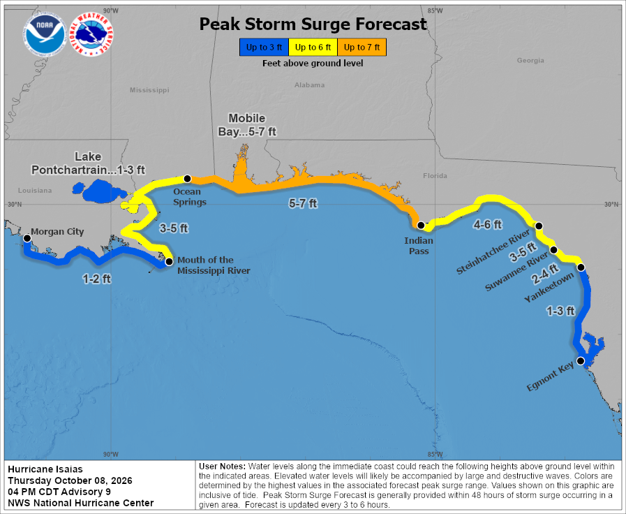
- 5 to 7 ft Ocean Springs, MS to Indian Pass, FL · 5 to 7 ft Mobile Bay · 4 to 6 ft Indian Pass to the Steinhatchee River · 3 to 5 ft mouth of the Mississippi River to Ocean Springs · 3 to 5 ft Steinhatchee River to Suwannee River · 2 to 4 ft Suwannee River to Yankeetown
- Landfall
- Within the warning area on the U.S. northern Gulf Coast, late Friday or early Saturday · turn north Friday · center inland along the northern Gulf coast within about 36 hours of 2100 UTC Thursday
- NHC intensity forecast
- Peak 95 kt (110 mph) at 09/0600Z near 25.7N 88.4W · 85 kt (100 mph) at 09/1800Z near 28.2N 87.4W · inland 65 kt (75 mph) at 10/0600Z near 31.0N 87.2W · post-tropical inland by Sunday · dissipated by Monday
All facts (10)
- Rain (updated)
- 4 to 8 in. southern Alabama, Florida Panhandle and Big Bend, and southwest Georgia, localized up to 15 in. · coastal Carolinas 3 to 5 in., locally up to 8 · remainder of the Southeast 1 to 3 in., locally up to 5 · flash and urban flooding likely · considerable impacts possible in southern Alabama and the Florida Panhandle into southwestern Georgia · river flooding expected, some possibly significant
- Tornadoes
- Isolated tornadoes possible Friday night in coastal Alabama, the Florida Panhandle and far southwestern Georgia · Saturday for eastern Alabama, Georgia, and the Florida Panhandle
- Key messages
- Life-threatening surge from mouth of the Mississippi to Suwannee, FL · evacuate if told · long-duration power outages in Hurricane Warning area · damaging inland gusts possible over central/northern Alabama, extreme eastern Mississippi, and portions of western/northern Georgia · heavy rain and flooding Friday into the weekend
- Next
- Intermediate advisory 700 PM CDT · complete advisory 1000 PM CDT · Forecaster Pasch

A life-threatening storm surge is expected from the Mouth of the Mississippi River to Suwannee, Florida. Residents in the warning area should follow advice given by local officials and evacuate immediately if told to do so.
NOAA NHC, Hurricane Isaias Discussion 9, Key Message 1, 400 PM CDT Thu Oct 8 2026
Note
At NHC Advisory 9, 4 PM CDT (5 PM EDT) Thursday, October 8, the eye of Hurricane Isaias was near 24.4 North, 89.3 West, about 215 miles north of Progreso, Mexico, and about 325 miles south of the mouth of the Mississippi River. Maximum sustained winds have increased to near 100 mph, with the pressure still estimated at 975 mb. Isaias is moving northeast at 12 mph. Hurricane-force winds extend outward up to 15 miles from the center, and tropical-storm-force winds now reach outward up to 125 miles.
Watches and warnings are unchanged with this advisory. A Storm Surge Warning remains in effect from the mouth of the Mississippi River to the Suwannee River, Florida. A Hurricane Warning covers Ocean Springs, Mississippi to the Bay/Gulf County line in Florida. Tropical Storm Warnings cover the Jefferson and Plaquemines Parish line in Louisiana to west of Ocean Springs, and east of the Bay/Gulf County line to the Aucilla River. A Storm Surge Watch covers the Suwannee River to Yankeetown. NHC says preparations to protect life and property from storm surge and damaging winds in the warning area should be rushed to completion today.
A turn toward the north is expected on Friday. On the forecast track, Isaias is expected to pass north of the Yucatan Peninsula through this evening and make landfall along the U.S. northern Gulf Coast within the warning area late Friday or early Saturday. Additional strengthening is expected through early Friday, and Isaias should remain a dangerous hurricane as it approaches the northern Gulf Coast Friday night. Discussion 9 says the eye has become apparent on visible and infrared satellite imagery, the first eye noted on satellite pictures in the Atlantic basin during the 2026 season. Tail Doppler Radar wind velocities from NOAA Hurricane Hunter aircraft measured just above the surface support raising the intensity to 85 knots for this advisory. The official intensity forecast peaks at 95 knots, about 110 mph, at 09/0600Z near 25.7 North, 88.4 West, then 85 knots at 09/1800Z near 28.2 North, 87.4 West, and 65 knots inland near 31.0 North, 87.2 West at 10/0600Z. Warm Gulf water favors further strengthening overnight, but vertical wind shear is expected to increase substantially during the next 36 hours, so some decrease in intensity is indicated as Isaias approaches the coast. Regardless, NHC expects Isaias to remain a dangerous hurricane through landfall, with strong gusty winds well inland after the center crosses the coast.
If the peak surge arrives at high tide, water could reach 5 to 7 feet above ground from Ocean Springs, Mississippi to Indian Pass, Florida, and in Mobile Bay; 4 to 6 feet from Indian Pass to the Steinhatchee River; 3 to 5 feet from the mouth of the Mississippi River to Ocean Springs and from the Steinhatchee River to the Suwannee River; and 2 to 4 feet from the Suwannee River to Yankeetown.
From Friday through the weekend, NHC now forecasts 4 to 8 inches of rain across southern Alabama, the Florida Panhandle and Big Bend, and southwest Georgia, with localized totals up to 15 inches, particularly within banding across the Florida Panhandle and Big Bend. Across the coastal Carolinas, rainfall of 3 to 5 inches, with localized totals up to 8 inches, is possible. Rainfall of 1 to 3 inches, locally up to 5, is possible across much of the remainder of the Southeast. Flash and urban flooding is likely, with considerable impacts possible across much of southern Alabama and the Florida Panhandle into southwestern Georgia. River flooding is also expected, some of which could be significant. An isolated risk for tornadoes begins Friday night in coastal Alabama, the Florida Panhandle and far southwestern Georgia, then continues Saturday for eastern Alabama, Georgia, and the Florida Panhandle. The next intermediate advisory is due at 7 PM CDT. The next complete advisory is due at 10 PM CDT. Forecaster Pasch.
Why it matters
NHC says preparations in the warning area should be rushed to completion today. People from the mouth of the Mississippi River to the Suwannee River should evacuate immediately if local officials say so. Southern Mississippi, southern Alabama, and the Florida Panhandle should prepare for long-duration power outages. The storm does not stop at the coast: NHC expects damaging gusts well inland over Alabama and Georgia, and flooding rain across the Southeast into the Carolinas.
Sources
- NOAA NHC: Hurricane Isaias Public Advisory 9 (latest public advisory page)
- NHC Hurricane Isaias Discussion 9 (latest discussion page)
- NHC Hurricane Isaias Forecast Advisory 9
- NHC graphics for AL09 Isaias (cone, warnings, peak surge, rainfall, rip currents)
- NHC CurrentStorms.json (al092026 Adv 009)
- Hero image: NOAA/NESDIS/STAR (GOES-19 GeoColor · 21:00 UTC Oct 8 2026)
- Figure (Map · NHC Advisory 9): NOAA NHC Advisory 9 GIS + preliminary best track
- Official graphic: NOAA/NHC
Primary + secondary attribution as listed.
More: Hurricanes & typhoons
Doom Signals desk · About · Contact · Corrections. Spotted an error? Write the desk; fixes go on the public log.