
official data (NOAA / NHC Public Advisory 23 + Discussion 23, 0900 UTC / 200 AM MST Sat Sep 26 2026 · Intermediate Adv 23A, 1200 UTC / 500 AM MST) · delta vs overnight Adv 22 Watch card · supersedes unpublished overnight Adv 22 and prior unpublished Adv 20 / 19 / 18
Polo Cat 5 — NHC: expected to make landfall in Baja California Sur Monday
NOAA’s National Hurricane Center Advisory 23 at 0900 UTC on September 26 kept Hurricane Polo an extremely dangerous Category 5 at 165 mph and 917 mb, then Intermediate Advisory 23A at 1200 UTC nudged intensity to 160 mph and 922 mb — and both public bulletins carried the same doom stamp: Polo is expected to make landfall in Baja California Sur on Monday as a powerful hurricane, with the Hurricane Watch still in effect from Punta Eugenia to Santa Fe and rainfall of 4 to 8 inches (max 10) across portions of Baja California Sur.
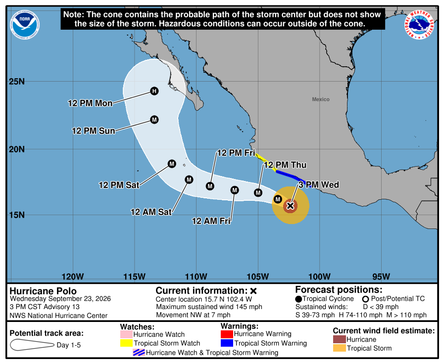
Key facts
- Adv 23 live stamp (0900 UTC / 200 AM MST Sat)
- Cat 5 · 165 mph · 917 mb · 17.6N 111.0W · WNW 9 mph · ~395 mi WSW Cabo Corrientes · ~375 mi S Cabo San Lucas
- Adv 23A live stamp (1200 UTC / 500 AM MST)
- Cat 5 · 160 mph · 922 mb · 17.7N 111.5W · WNW 10 mph
- Landfall stamp (both bulletins)
- EXPECTED TO MAKE LANDFALL IN BAJA CALIFORNIA SUR ON MONDAY AS A POWERFUL HURRICANE
- Discussion 23 intensity
- 145 kt (nudged from recon); powerful hurricane at Baja; likely still hurricane into NW mainland Mexico; finish prep by Sunday
- Watch
- Hurricane Watch still Punta Eugenia to Santa Fe; east-Baja watches likely later today; NW mainland Mexico monitor
- Wind timing
- Hurricane conditions possible in watch by Monday afternoon; TS southern watch Sunday night
- Rainfall
- 4–8 in (max 10) BCS — life-threatening flooding/mudslides
- Delta vs overnight Adv 22
- Watch-issued / Monday-evening window / 175 mph → explicit landfall Monday / Monday-afternoon window / 165→160 mph
- Supersedes
- Unpublished overnight Adv 22; unpublished Adv 20 / 19 / 18 — do not ship Adv 22 if shipping Adv 23
- Live later
- Next complete advisory · east-Baja / NW mainland watches · warning upgrades · landfall timing revision → HUD — no invented landfall hour or death toll
…EXPECTED TO MAKE LANDFALL IN BAJA CALIFORNIA SUR ON MONDAY AS A POWERFUL HURRICANE…
NHC Public Advisory Number 23 / Intermediate 23A · Sat Sep 26 2026 · Adv 23: 165 mph / 917 mb · Adv 23A: 160 mph / 922 mb
Note
National Hurricane Center Advisory 23, issued for 200 AM MST on September 26, kept Hurricane Polo at Category 5 and put the landfall word on the public bulletin. Sustained winds 165 mph, pressure 917 millibars, center near 17.6 north, 111.0 west — about 395 miles west-southwest of Cabo Corrientes and 375 miles south of Cabo San Lucas — moving west-northwest at 9 mph. The headlines call it an extremely dangerous Category 5 and say it is expected to make landfall in Baja California Sur on Monday as a powerful hurricane. Discussion 23 cites overnight NOAA aircraft and nudges intensity to 145 knots, still forecasting a powerful hurricane at Baja and a likely hurricane into northwestern mainland Mexico, with preparations to finish by Sunday. Intermediate Advisory 23A at 500 AM MST repeated the landfall headline at 160 mph and 922 mb near 17.7 north, 111.5 west, kept the Hurricane Watch from Punta Eugenia to Santa Fe, and flagged that watches will likely be required for the east coast of Baja later today while northwestern mainland Mexico monitors.
Hurricane conditions are possible in the watch by Monday afternoon, with tropical-storm conditions possible in the southern portion Sunday night. Rainfall of 4 to 8 inches, isolated 10, still sits on the bulletin for portions of Baja California Sur, with life-threatening flooding and mudslides in steep terrain. The overnight Adv 22 Watch card is superseded — this note is the Saturday landfall stamp. Next advisories, east-Baja watches, and any landfall revision stay on the HUD.
Why it matters
Category 5 is still on the board at dawn — and the National Hurricane Center just put “expected to make landfall” on the public product for Baja California Sur on Monday. Official product now pairs peak-class intensity with an explicit Monday landfall line and a coastal watch already up — intensity plus geography, not a carnival death call.
Sources
- NOAA National Hurricane Center
- NHC Discussion 23
- NHC Intermediate Advisory 23A
- NHC live Public (TCPEP2)
- NHC EP172026 archive
- NHC graphics (5-day cone)
- Prior boarded Adv 14 card
Primary + secondary attribution as listed. Live values go to the HUD / source product.