
official data (NOAA / NHC Public Advisory 27 + Discussion 27 + Forecast/Advisory 27, 0900 UTC / 200 AM MST Sun Sep 27 2026) · supersedes boarded Adv 25 card
Polo holds at Cat 3 — Hurricane Warnings now on both Baja California Sur coasts
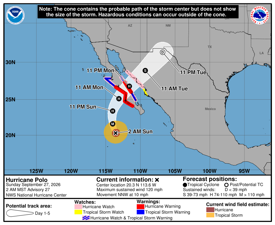
NOAA’s National Hurricane Center Advisory 27 at 200 AM MST on September 27 holds Hurricane Polo at Category 3 — 120 mph, 952 mb, near 20.3 north, 113.6 west — and the government of Mexico has added a Hurricane Warning for the east coast of Baja California Sur from Loreto to Santa Rosalia, alongside the west-coast warning from Punta Abreojos to Santa Fe, with a Hurricane Watch now up for mainland Mexico from Huatabampito to Bahia Kino. NHC says preparations to protect life and property should be rushed to completion in Baja California Sur.
Key facts
- Adv 27 live stamp (0900 UTC / 200 AM MST Sun)
- Cat 3 · 120 mph (195 km/h) · 952 mb · 20.3N 113.6W · NNW (330°) at 10 mph · ~300 mi SW Cabo San Lucas · ~320 mi SSW Cabo San Lazaro
- Headlines (Adv 27)
- NEW WATCHES AND WARNINGS ISSUED FOR PORTIONS OF BAJA CALIFORNIA AND MAINLAND NORTHWESTERN MEXICO · PREPARATIONS TO PROTECT LIFE AND PROPERTY SHOULD BE RUSHED TO COMPLETION IN BAJA CALIFORNIA SUR
- Hurricane Warning
- West coast of Baja California Sur, Punta Abreojos to Santa Fe (issued Adv 26) · NEW: east coast of Baja California Sur, Loreto to Santa Rosalia
- Hurricane Watch
- West coast BCS north of Punta Abreojos to Punta Eugenia · east coast BCS south of Loreto to San Evaristo · east coast BCS north of Santa Rosalia to Bahia San Juan Bautista · NEW: mainland Mexico, Huatabampito to Bahia Kino
- Tropical Storm Warning
- West coast BCS north of Punta Abreojos to Punta Eugenia · NEW: east coast BCS south of Loreto to San Evaristo · NEW: east coast BCS north of Santa Rosalia to Bahia San Juan Bautista
- Tropical Storm Watch
- NEW: mainland Mexico south of Huatabampito to Topolobampo · interests in the rest of Baja California Sur, Sonora and northern Sinaloa should monitor
- Forecast track (Adv 27)
- NNW now; turn north later today, northeast Monday; on the forecast track, approaches the west coast of Baja California Sur Monday, crosses the peninsula Monday night, approaches NW mainland Mexico by early Tuesday
- Discussion 27 intensity
- Held at 105 kt · hints of an eye in geostationary and microwave imagery · TAFB Dvorak current intensity 6.5/127 kt, final-T 5.5/102 kt · UW-CIMSS objective estimates 105–110 kt · NOAA aircraft mission ended about 7 h before the advisory
- Discussion 27 outlook
- Fairly weak shear and water near 29C for 24 h, drier air ahead; southwesterly shear increases by hour 36, about 6 h before landfall — gradual weakening until then, rapid weakening after; no restrengthening expected in the Gulf of California; some possibility Polo is still a hurricane at a second landfall in mainland Mexico (HAFS-A); dissipates inland over northern Mexico by hour 72
- Forecast max winds (Discussion 27)
- INIT 105 kt · 12H 100 · 24H 95 · 36H 90 · 48H 70 · 60H 40 · 72H 25 post-tropical/inland · 96H dissipated
- Track confidence (Discussion 27)
- Largest uncertainty is forward speed through the northeast turn; model spread higher than unusual at 48–72 h, more so after landfall; NHC follows the GDMI/HCCA path but a bit slower — essentially on top of the previous forecast
- Wind timing
- Hurricane conditions expected in the west-coast warning area by Monday afternoon; tropical-storm conditions possible in its southern portion by tonight into early Monday, spreading north Monday and east across Baja California Sur Monday evening; hurricane conditions possible in the mainland Mexico watch area Tuesday
- Wind field (Adv 27)
- Hurricane-force winds extend up to 45 mi (75 km); tropical-storm-force up to 125 mi (205 km)
- Rainfall
- 4–8 in (max 10) across portions of Baja California Sur — life-threatening flooding and mudslides possible, especially in steep terrain
- Surge / surf
- Surge could produce significant coastal flooding in areas of onshore winds, with large and destructive waves; life-threatening surf and rip currents along SW and west-central Mexico and Baja California Sur, spreading north along the peninsula
- Southwest US moisture (Discussion 27)
- Distant moisture from Polo and Odalys moves into the southwestern United States late this weekend and early next week and may indirectly contribute to a heavy rainfall and flash flood threat — see WPC
- Overnight chain
- Adv 26 (0300 UTC / 800 PM MST Sat): Cat 3 · 120 mph · 949 mb · 19.3N 113.1W · Hurricane Hunters find Polo still a major hurricane; Hurricane Warning issued west coast BCS · Intermediate 26A (0600 UTC / 1100 PM MST): 120 mph · 950 mb · 19.8N 113.4W · no watch/warning changes
- Delta vs boarded Adv 25
- Cat 4 · 145 mph · 938 mb · Hurricane Watch only (Punta Eugenia–Santa Fe) → Cat 3 · 120 mph · 952 mb · Hurricane Warnings on both Baja California Sur coasts · Hurricane Watch mainland Mexico
- Supersedes
- Saturday Adv 25 Cat 4 card and the Sep 24 Adv 14 Cat 5 card — both off the board; both pages stay live in the archive
- Live later
- Intermediate 27A (500 AM MST / 8 AM EDT) · Adv 28 (800 AM MST / 11 AM EDT) · Sonora / Sinaloa watch changes · landfall timing → HUD — no invented landfall hour or death toll
…PREPARATIONS TO PROTECT LIFE AND PROPERTY SHOULD BE RUSHED TO COMPLETION IN BAJA CALIFORNIA SUR…
NHC Public Advisory Number 27 · 200 AM MST Sun Sep 27 2026 · Cat 3 · 120 mph / 952 mb
Note
National Hurricane Center Advisory 27, issued for 200 AM MST on Sunday, September 27, holds Hurricane Polo at Category 3. Sustained winds 120 mph, pressure 952 millibars, center near 20.3 north, 113.6 west — about 300 miles southwest of Cabo San Lucas — moving north-northwest at 10 mph. The headlines say new watches and warnings have been issued for portions of Baja California and mainland northwestern Mexico, and that preparations to protect life and property should be rushed to completion in Baja California Sur. On the forecast track Polo turns north later today and northeast on Monday, approaches the west coast of Baja California Sur Monday, crosses the peninsula Monday night and approaches northwestern mainland Mexico by early Tuesday.
Mexico added a Hurricane Warning for the east coast of Baja California Sur from Loreto to Santa Rosalia; the west-coast warning from Punta Abreojos to Santa Fe, issued Saturday night after NOAA Hurricane Hunters found Polo still a major hurricane, stays up. A Hurricane Watch now covers mainland Mexico from Huatabampito to Bahia Kino, with a Tropical Storm Watch south of Huatabampito to Topolobampo, and Tropical Storm Warnings cover the east-coast stretches north and south of the new warning. Hurricane conditions are expected in the west-coast warning area by Monday afternoon, tropical-storm conditions are possible in its southern portion as soon as tonight, and hurricane conditions are possible in the mainland watch area on Tuesday. Hurricane-force winds reach 45 miles from the center; rainfall of 4 to 8 inches, isolated 10, may produce life-threatening flooding and mudslides across portions of Baja California Sur.
Discussion 27 holds intensity at 105 knots, with hints of an eye still showing on satellite, and keeps Polo in fairly weak shear over water near 29C for another day — only gradual weakening until southwesterly shear arrives about six hours before landfall, then rapid weakening. It flags some possibility that Polo is still a hurricane at a second landfall in mainland Mexico, and says track-model spread on forward speed remains higher than unusual between 48 and 72 hours. This supersedes the Saturday Adv 25 Cat 4 card; that page and the Sep 24 Cat 5 card stay live in the archive. Intermediate 27A and the next complete advisory go to the HUD.
Why it matters
The wind number has held at Category 3 since Saturday night; the warning map keeps growing. Hurricane Warnings now sit on both coasts of Baja California Sur, mainland Mexico is under a Hurricane Watch, and the bulletin has moved to rush-to-completion language with the Monday approach still on the track. Official product, not a death count.
Sources
- NOAA National Hurricane Center
- NHC Discussion 27
- NHC Forecast/Advisory 27
- NHC Public Advisory 26 (Hurricane Warning issued, west coast)
- NHC Intermediate Advisory 26A
- NHC live Public (TCPEP2)
- NHC EP172026 archive
- NHC graphics (5-day cone)
- Superseded Adv 25 card (archive)
- Earlier Adv 14 Cat 5 card, Sep 24 (archive)
Primary + secondary attribution as listed. Live values go to the HUD / source product.