
official data
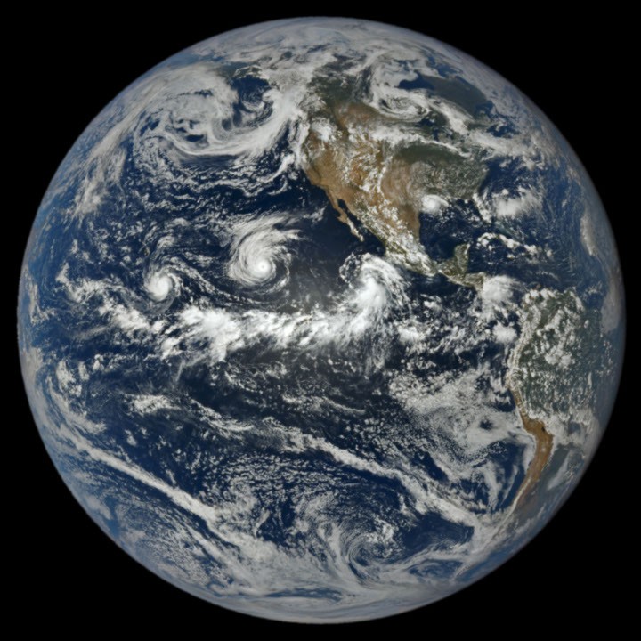
NASA’s deep-space camera caught three Pacific storms at once
A NASA Earth Observatory Image of the Day shows DSCOVR’s EPIC camera capturing Lowell, Karina, and Marie churning together in the Pacific on September 1 — while the Atlantic stayed unusually quiet under El Niño’s imprint.
Key facts
- IOTD date
- 4 Sep 2026 — story Adam Voiland; image Lauren Dauphin using DSCOVR EPIC data
- Acquisition
- 1 Sep 2026, 20:14 UTC (1:14 p.m. PDT) — EPIC on DSCOVR, nearly 1 million miles from Earth
- Pacific trio
- Lowell (later Cat 5 for several hours on 2 Sep) · Karina (Cat 4 around same time) · Marie (tropical storm in frame, strengthening NW of Baja)
- Rare pair
- EO notes rare simultaneous Cat-4 and Cat-5 pair in the area
- Atlantic in frame
- Tropical Storm Edouard over Louisiana/Texas shortly after landfall; NWS-cited rains 15–24 inches in some areas (EO story)
- Season context (EO / CSU as of 3 Sep)
- NE Pacific 15 named / 6 hurricanes; Atlantic 5 named / 0 hurricanes; Atlantic ACE 4.4 (~9% of normal); NE Pacific ACE 130 (~50% above normal)
- Scope
- EO image/memory card only — live Lowell Adv 56 / Fourteen-E remain overnight HOLD; not merged into this slug
One deep-space frame holding three Pacific cyclones — including a Cat-4/Cat-5 double — is the season’s instrument-panel postcard. The Atlantic quiet in the same view is the El Niño contrast written in cloud.
Desk reading of NASA Earth Observatory IOTD
Note
From nearly a million miles out, EPIC did not have to choose a favorite. On September 1 it caught Lowell, Karina, and Marie sharing the Pacific while Tropical Storm Edouard sat over the western Gulf Coast. NASA’s September 4 Image of the Day makes the seasonal argument in one photograph: the eastern Pacific was crowded enough for a rare same-time Category 4 and 5, and the Atlantic’s ACE was still a fraction of normal. This card is the picture. The live track meters belong on the NHC board already held overnight.
Attribution: NASA Earth Observatory — “A Trio of Tropical Cyclones in the Pacific,” Image of the Day 4 Sep 2026 (EPIC/DSCOVR image 1 Sep 2026). JTWC product URLs returned AccessDenied at fetch and were not used.
Why it matters
Desk keeps this as the image/memory card; overnight Radar already HOLDs live Lowell Adv 56 and Fourteen-E — do not merge those live meters into this EO slug.
Sources
Official data. Live values go to the HUD / source product.