
official data (NASA Earth Observatory Image of the Day) · NOAA NCEI national climate (warmest CONUS summer)
NASA: mid-September heat dome put 41 million Americans under extreme heat alerts
NASA’s Earth Observatory Image of the Day for September 17 maps a mid-September heat dome over the south-central United States — more than 41 million people under National Weather Service extreme-heat products on September 15, with Dallas at 101°F and Nashville breaking a daily-high record that had stood since 1927 — after NOAA already stamped June–August 2026 as the warmest contiguous-U.S. summer in a 132-year record.
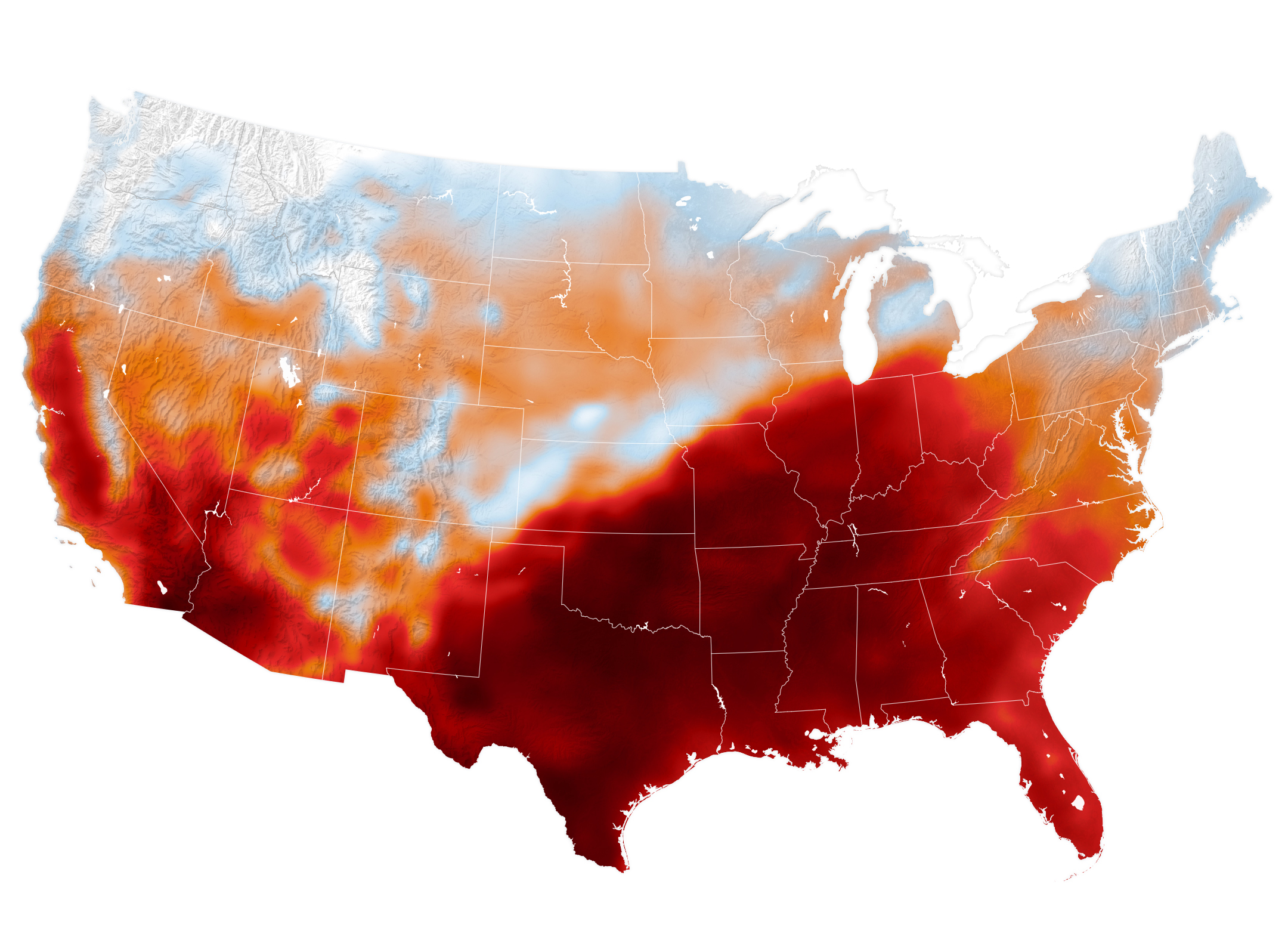
Key facts
- Product
- NASA Earth Observatory Image of the Day — “Summer Goes Out With a Heat Dome” — Sep 17, 2026. Story by Lindsey Doermann; image by Michala Garrison using GEOS-FP (NASA GMAO).
- Map stamp
- Modeled air temperature at 2 m above ground, contiguous U.S., Sep 15, 2026, 4 p.m. Central Time (21:00 UTC); darkest reds approach/exceed ~40°C (104°F).
- Alert count (NASA citing NWS)
- More than 41 million people (~12% of U.S. population) under NWS extreme heat advisory / watch / warning on Sep 15.
- Geography named
- Large portions of Texas, Oklahoma, Arkansas, Missouri, Tennessee.
- Station records (NASA)
- Dallas 101°F (38°C); Memphis 99°F (37°C); Nashville 100°F (38°C) on Sep 15 — all ≥12°F above normal; Nashville breaks daily-high record from 1927; Sep 14 Nashville record-high minimum 75°F (24°C).
- Mechanism (NASA)
- Heat dome — upper-atmosphere high pressure pushes hot air to the surface and traps it; suppresses convection, clouds, precipitation; more sunlight reaches the ground.
- Seasonal context (NASA citing NOAA)
- Follows warmest June–August for contiguous U.S. in 132-year record; JJA 2026 0.4°F warmer than prior records (1936 and 2021).
- NOAA NCEI national (Sep 9, 2026)
- CONUS JJA 2026 average 74.4°F — warmest summer on record; August CONUS 75.6°F — warmest August on record; drought 59.1% of CONUS on Sep 1.
- Live
- Later station records / alert counts → live NWS / Heat.gov HUD. Desk does not invent a post–Sep 15 national alert tally.
The calendar said almost-fall. The map still said oven.
Desk reading of NASA Earth Observatory Image of the Day (Sep 17, 2026)
Note
NASA’s Earth Observatory on September 17 published a GEOS-model temperature map of the contiguous United States for 4 p.m. Central Time on September 15 — a mid-September heat dome over the south-central states, with the darkest reds approaching 40°C. More than 41 million people, about 12 percent of the U.S. population, were under National Weather Service extreme heat advisories, watches, or warnings that day across large parts of Texas, Oklahoma, Arkansas, Missouri, and Tennessee. Dallas hit 101°F, Memphis 99°F, and Nashville 100°F — Nashville breaking a daily-high record from 1927 after a record-high overnight minimum of 75°F the day before. NASA attributes the pattern to a heat dome: upper-level high pressure trapping hot air and suppressing clouds. The stretch follows NOAA’s stamp that June–August 2026 was the warmest contiguous-U.S. summer in 132 years, 0.4°F above the 1936 and 2021 marks.
Attribution: NASA Earth Observatory IOTD Sep 17, 2026 (Lindsey Doermann / Michala Garrison / GEOS-FP). Seasonal record: NOAA NCEI national climate August 2026 overview (Sep 9, 2026). Live later alerts → NWS / Heat.gov — not this note.
Why it matters
Forty-one million people inside extreme-heat products in mid-September is the late-season panel: the dome did not get the equinox memo, station records fell on a Tuesday that should have been cooling, and NOAA already wrote the warmest contiguous-U.S. summer into the 132-year book. Pair with Lake Powell’s bathtub ring — heat and water storage on the same Southwest stress ledger, different official stamps.
Sources
- NASA Earth Observatory
- NOAA NCEI — Warmest summer on record for the contiguous U.S.
- NOAA NCEI — global August 2026 context
Primary + secondary attribution as listed. Live values go to the HUD / source product.